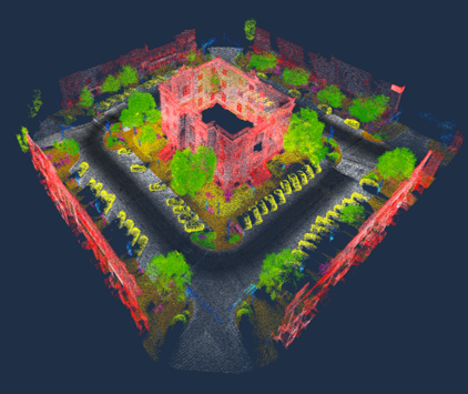
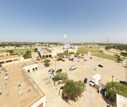
DIGITAL TWINS
BUILD. SHARE. EXPERIENCE


CREATING A DIGITAL TWIN
OF COMMUNITIES
CAPTURING DATA
local content creators or experts can capture digital twin data based on geographic and data requirements.
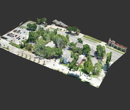
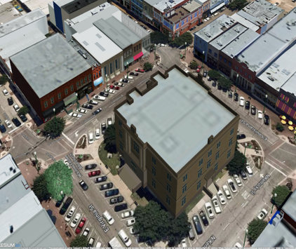
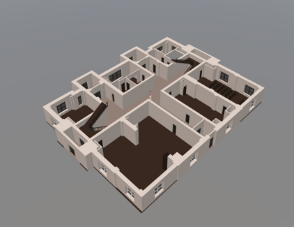
3D MODELING
3D models of community infrastructure will be loaded into a platform that the community can access.
CROWDSOURCING
Providing communities and locations with the ability to capture and maintain 360 panoramic photos, point cloud, ortho and other data from staff or public.
PROVIDING COMMUNITIES WITH THE RESOURCES TO BUILD
DIGITAL TWINS WILL ALLOW RESIDENTS AND BUSINESSES TO
INTERACT IN NEW AN INNOVATIVE WAYS

WHAT SEPTRIO CAN BE USED FOR
5G Preparations
Advertising
Infrastructure
Management
Event Planning
Erosion Control


Marketing
Timeline Analysis
Economic
Development
Chestnut Square link
3D models - downtown link
Lidar - downtown McKinney link
Chestnut Square Church link
POI @ 80 ft link
MPAC Floor plan link
OUR VISION
Our vision is to unify communities by providing them with the resources and knowledge base needed to build and maintain digital twins that include 3D models of community infrastructure. The twins will synthesize BIM and OpenStreetMap data to allow optimization of everyday processes from customer service to community development to marketing. Community members can benefit from a crowdsourced digital twin by allowing them to share their digital locational data and interact with that of others.
WHO CAN USE SEPTRIO
Local Governments | Communities | Chambers of Commerce
Inspection Agencies | Businesses | Residents | Schools
Build. Share. Experience
Build
We follow a crowdsourced approach in building our digital twin platform. We use OpenStreetMap data as a baseline and will be using a broad array of inputs such as standard phones, panoramic cameras, as well as 3D modeling programs. Until very recently, only large organizations could afford technology to capture and store such high quality data, as platforms that currently store and access data are very expensive to run and maintain.

In recent years, technology innovations have helped lower these costs, but they are still out of reach for the small business owners or residents. This is not because of the costs required to capture information, but because there is no platform or mechanism to store and share that information with other residents or community members. Our system will share both the costs and benefits of maintaining a digital twin.
Share
Our vision is to unify communities by providing them with the resources and knowledge base needed to build and maintain digital twins that include 3D models of community infrastructure. The twins will combine BIM and OpenStreetMap data to allow optimization of everyday processes from customer service to community development to marketing. Community members can benefit from a crowdsourced digital twin by allowing them to share their digital locational data and interact with that of others.
Experience
This will create a new digital sector in the market where people can engage and interact with other residents, creators, developers, and marketers. This platform promotes STEM education, innovation, and collaboration by giving a community the ability to create and manage a digital twin and also provide a framework for IOT and Smart Cities.

Every member of the community can benefit from a crowdsourced digital twin by allowing them to share their digital locational data. Some examples of this data can be a simplified BIM of their building, asset infrastructure at a local park, or a downtown business district. Digital owners can share data to other residents, business owners or the public. They can also be shared in co-op marketing or within gaming platforms like RealEngine or Unity as assets for location based games
Still have questions?
Ask us and we will gladly
get back to you!
CONTACT US
Want to learn more and see if Septrio is a good fit
for you? Fill out the form below to get in touch.